
Windstorm Damage at 245 Searsport Avenue

A heavy wind storm hit Belfast, Maine on the night of 10 January 2024 at high tide causing flood and wind damage to buildings and boats near the harbor. As you can see in the above photo of the Belfast Harbor-master’s Office, the water with breaking waves on it topped the breakwater, docks, and parking surfaces. Extensive damage was done to the nearby Nautilus Restaurant.
Our neighbor Leann Ferland asked another neighbor to take some pictures during the storm and the next day. First, the photo below (clipped from a video) was captured from the front yard of the house down the street from hers, where a small arm of the bay penetrates a thousand feet or so inland up to Route 1. Normally an empty, shrub-filled wash it then hosted substantial waves racing inward and breaking on the little islands of trees and eventually the shore. Note at right the breaking surf is stained yellow with the dirt it is eroding off the shore-front and beach.

The next day, more pictures were taken in brilliant sunshine. In the first, it is clear from his shadow that the photographer was standing some ways down on the Saglia’s beachfront on what was usually a dry flat surface evenly covered in small pebbles and shale and rocks … a rubble-beach. It is now mostly wet sand and bigger rocks. Clearly rocks have been thrown violently against the trees and shrubs that filled the area between the normal high tide line and the Saglia’s lawn. Their short staircase appears unharmed. Looking straight ahead toward the Saglia’s white Gazebo, you can see just how deeply the land was carved out by waves breaking at high tide against the edge of their lawn. Erosion has created a vertical cliff topped with turf. Even the rubble-beach stones have been swept away from the bottom of the dirt cliff.

OK …. What is the enormous concrete structure that has been exposed by serious beach erosion? In 2007, we learned from Larry Dean that there was evidence of an ancient shipyard on the Saglia’s property and a marine railway leading downhill and out into the bay. It is enjoyable to think that ships were built where we live. Behold the solid wall and badly rusted rails that might be what’s left of that ship transport system. The wall is just about where normal high tide falls. The notch in the center of the wall might be where the rail system was attached.

The above two photos were taken from the Ferland’s lawn. Remember that it used to have a substantial wooden staircase leading down to the beach and they built a fire-pit.
That staircase is gone as is the fire pit. The new drop-off to the sand below is startling. Leann pointed out that in the lower right corner, you can see the concrete slab that used to support the top of the staircase.
This new staircase was added by the folks at the South-East corner of Highview Terrace. In addition, a very substantial amount of rock was deposited at the bottom both to stabilize the stairs and to reinforce the steep bank. Apparently, a lower section of stairs was torn off in the storm despite this effort. The bank was deeply eroded.
We have as yet no real data or images of our own seafront.
To be continued….

Email message to Leann and Joe, 15 January 2024
Bill and Jill Kulbe, from Banks Terrace, went to our property and took some more photos of the storm damage. They thought they had found your beach staircase, but It could also be the lowest section of the stairs missing at the end of Highview Terrace.
Erosion was perhaps not as severe at our property because we had a substantial buffer of trees, saplings, shrubs, etc between the ocean and our lawn. These took a terrible beating. Also, wave action was attenuated by the offshore reef which is more directly in front of our house than yours or the Saglias.
The shorefront trees took quite a bashing from waterborne rocks, but some are still attached to the ground as seen in the photo below.

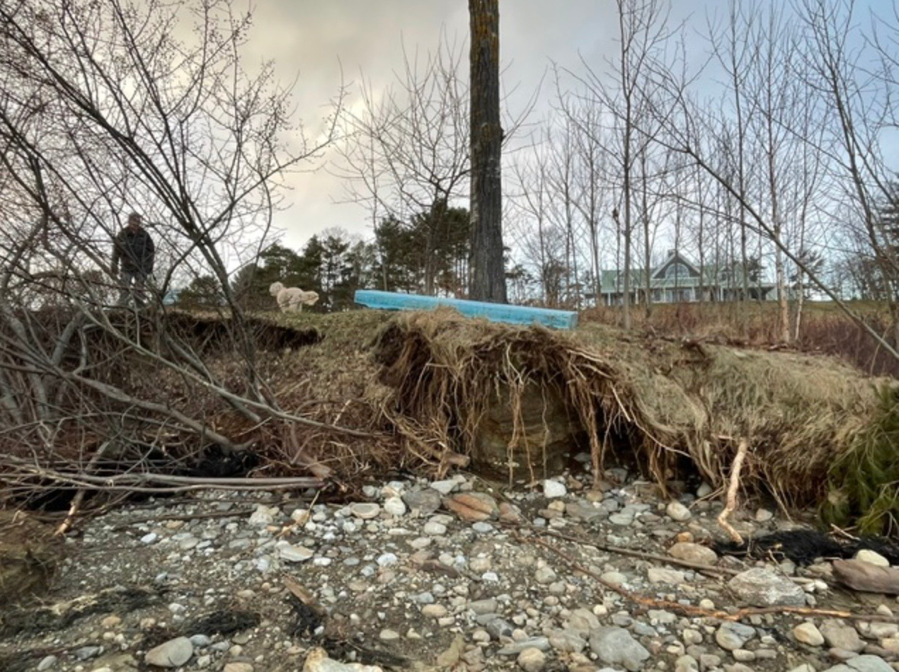
Like yours, our rocky pebble-beach was scoured away pretty completely. Your pictures revealed the previously hidden head-wall of the marine railway now visible on the Saglia’s beach. That’s evidence of how much pebble-beach material was clawed away. Here is how the sea bottom looks looking out to sea. Here is the new shoreline from directly in front of our house. The blue object is styrofoam. We will, no doubt, loose the big Poplar tree.
Below is a full gallery of Bill & Jill’s pictures from 15 January 2024 that tell the tale, including two views of the staircase, which looks mostly intact. You can click through all the pictures here.


And finally, here are photos of Shoreline Damage taken on 20 January 2024 by Brad Rollerson, our long-term Property Manager.


Photo 1. In this photo, Brad was standing at the new edge of our lawn well to the West of the big Poplar tree. Larry Saglia’s white cupola can be seen way down the shore. Several feet of the embankment all along here has collapsed, carrying away several feet of soil and turf. There is little left of the small and large trees that grew on this embankment and at it's foot. However, it appears that the big, healthy pine that is at the seaward end our Western property line with the Saglia's may be still upright.
Photo 2. Standing at the new edge of our lawn, still well to the West of the big Poplar tree. Looking toward Leann Ferland’s house. A few large trees growing below the embankment, are still l upright. Note the pair of Birches. There is even a heroic group of saplings hanging on way down the old embankment. Our large Poplar tree is visible further along the beach. Note it may now be leaning inland. Not surprising because of the very limited root-ball remaining after heavy erosion.
Photo 3. This is probably a detail of the undercut bank taken from even closer to the Poplar tree, just beyond the pair of Birches visible in the previous picture. The trees that were growing here have slid down the embankment a long way.
Photo 4. Brad is now standing just a few feet to the West of the poplar tree, now right at the new edge of our lawn. Looking down the beach towards Leann’s place. Note the deep cut into the soil at the seaward edge of the Poplar. In the foreground is a large blue Styrofoam float that was once someone’s dock. Its position indicates how high the tide and waves were at the peak of the storm. Observe from the crack in the snow that the new edge of our lawn runs under this block and within a few feet of the Poplar tree. Just beyond is a complete, intact, long staircase that floated in on the waves. It probably belongs to the folks at the corner of the road next door in Highview Terrace.